
Braving New Zealand’s Old Ghost Road
The Old Ghost Road is one of those rare places where reality exceeds the hype.
A relatively new addition to Aotearoa’s smorgasbord of multi-day walks — it only opened in 2015 — it was the first track designed specifically for dual use by trampers and mountain bikers.
It’s also unusual because, despite being on public conservation land, it’s not built or operated by DOC but by a private trust.
The 85km track passes though a storied landscape where you almost feel the presence of early explorers and prospectors, first Māori, later European, who left their mark in the form of mining relics, evocative place names and graves.
Even the track itself has a great back story.
Its origins go back to the 1880s when plans were drawn up for a road linking Lyell, then a busy mining settlement, with the mighty Mōkihinui River to the north.
A dray road just wide enough for a horse-drawn cart was built as far as Lyell Saddle, where the first hut is today, before the project petered out along with the West Coast’s gold.
Any hopes of reviving the Lyell-Mōkihinui road were dashed by the Murchison Earthquake (magnitude 7.8) in 1929 and the Inangahua Earthquake (7.1) of 1968, which unleashed massive landslides across the route of the old dray road. Legend has it the slips were so treacherous even goats wouldn’t dare cross them.
That was the end of the dream of a route between Lyell and the Mōkihinui River … until 2007, when an American ex-pat living on the coast stumbled on a 19th century survey map showing the proposed Lyell-Mōkihinui road.
The map planted an idea in Marion Boatwright’s head of creating a hiking trail through the wild backcountry of the Lyell Range.
He set up the Lyell-Mōkihinui Backcountry Trust and persuaded a few skilled locals to join him, in particular bushman Steve Stack, chopper pilot Wayne Pratt and Phil Rossiter, then the environmental manager of the nearby Stockton Mine. Crucially — and this isn’t always the case when private groups try to open up New Zealand’s backcountry — his scheme also won the support of the local Department of Conservation (DOC) office.
Boatwright and Stack retraced what was left of the old dray road and found a route around the Big Slips to Lyell Saddle, then tried to find a way down the other side along the south branch of the Mōkihinui River as mooted in the 1886 survey map.
After weeks of bashing their way through dense bush and impossibly rugged terrain they realised their mission was futile. The number of bridges they’d need to build across side creeks and chasms would’ve made the project prohibitively expensive.
That setback, however, turned out to be the making of the Old Ghost Road.
During a helicopter survey they found what appeared to be a possible alternative route along the tops of the Lyell Range. From there walkers could drop into the Stern Valley via what would later be named Skyline Ridge, and eventually connect with the Mōkihinui River near the point where the south and north branches meet.
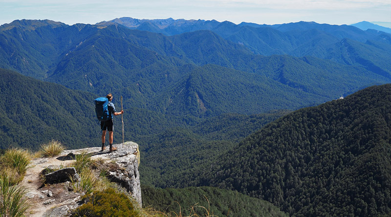
| Old Ghost Road highlights
• The scenery around Rocky Tor and the open tops of the Lyell Range. |
When DOC officially got on board in 2009 it was on the condition that the track be designed for dual use by trampers and mountain bikers.
By a stroke of luck the then John Key Government was planning a nationwide network of cycle trails to boost the economy after the financial crisis. Cash from the New Zealand Cycle Trail Fund was instrumental in making the track a reality, along with thousands of hours of volunteer labour.
In the project’s early stages the power company Meridian also contributed funding. The company planned a dam on the Mōkihinui River and was looking for a project it could support, with the aim of winning over local opposition. Later, as antipathy to the dam grew, the trust cut its ties with Meridian.
The dam plan was abandoned in 2012 and the river is now fully protected. Once you’ve walked the Old Ghost Road you’ll understand what a tragedy it would have been if the Mōkihinui Gorge had been flooded.
The Old Ghost Road finally opened in 2015. There were plenty of controversies along the way with, to name a few, conservationists outraged at the felling of a landmark tree or the carving of a track through the previously undisturbed Lyell Range, and sceptics questioning whether the route could ever be made passable for bikes. (The sceptics were eventually proved wrong but the track is a challenging grade 4-5 ride.)
More than five years later the Old Ghost Road appears to be a great success. It’s almost always booked out, even now that the country’s borders are closed by Covid-19.
If you’re used to DOC’s Great Walks you’ll notice a few differences on this trust-run track.
You still have to book a bunk at each hut but you pay a flat rate ($150 at the time of writing) regardless of how many nights you stay. That is, of course, in walkers’ favour because they generally take four nights to complete the track. That also makes it good value compared to a Great Walk where you usually pay around $45 a night.
For mountain bikers, on the other hand, it’s relatively expensive, especially for those staying just one night. That may reflect the greater cost of building and maintaining tracks used by bikes. When the Old Ghost Road first opened I was told it operated a pay-per-night system, but switched to a flat fee to encourage people to linger rather than charging through as quickly as possible.
Another thing that makes the Old Ghost Road different from a Great Walk is the huts. New DOC huts are generally built to a standard plan with plenty of space, solar-powered lights and even phone charging ports.
Along the Old Ghost Road, however, every hut is different. Built by Boatwright and a band of volunteer helpers, each is uniquely adapted to its site. They are less roomy than Great Walk huts and don’t have lighting but they do come equipped with pots, pans, mugs, cutlery and coffee plungers, a serious luxury in the backcountry. You’ll also find a shower at most huts, though you’ll have to heat the water and top up the bucket yourself.
If you don’t fancy sharing a hut with a dozen snorers the trust has also built private four-bunk cabins which can be booked for an extra fee.
The Old Ghost Road also stands out for its quirky, evocative place names — many of which were coined during track building — and the humour in the signs and notices. That’s something you don’t get from the rather more earnest DOC.
Hump Ridge in Southland is the only other multi-day walk I know of in New Zealand which is operated by a private trust, but not for much longer. In 2022 Hump Ridge will become the country’s 11th Great Walk.
Even before it opened the Old Ghost Road was hailed internationally as one of the world’s best single-track mountain bike trails. With that kind of publicity it’s not surprising that most users in its first years were mountain bikers.
A hut warden told me that pre-Covid 80 per cent of users were mountain bikers and the same proportion were overseas visitors. But when I walked the Old Ghost Road in February 2021 almost 100 per cent were Kiwis and more than two-thirds of those were walkers. Border closures account for the change in nationality of course, but the reason for the switch to tramping isn’t clear.
If you compare the Old Ghost Road and the Paparoa Track (a Great Walk a little further south), the Old Ghost Road is longer (85km vs 56km) and more demanding. It also has the edge in terms of scenery and variety.
Now don’t get me wrong, I loved the Paparoa Track. It’s just that the terrain traversed by the Old Ghost Road is on another level of spectacular.
While you’re walking in the Paparoa Ranges civilisation is almost always in sight somewhere in the distance but the Old Ghost Road traverses some truly wild country. It would have been impenetrable to all but the hardiest trampers before the track was built.
I sometimes hear the Old Ghost Road compared to the Heaphy Track, a Great Walk linking Golden Bay and the top of the West Coast. Personally I don’t see the similarity, but what they do have in common is distance and variety. On both walks you’re treated to entirely different landscapes and ecosystems every day.
So why did it take an ex-pat American to see the potential of the Lyell-Mōkihinui backcountry, then push a track through despite many physical and financial challenges?
In his book Spirit to the Stone, Boatwright explains it like this:
“It’s like this backcountry is your seriously hot sister, but because she’s your sister you can’t see how gorgeous she really is … Well, she’s not my sister, and that goes for the folks that are gonna do this trail, even the Kiwis.”
In other words, it took an outsider to show us what was in front of our faces. We Kiwis are so surrounded by beauty we sometimes become blind to it.
Walking the Old Ghost Road
The Old Ghost Road is said to be one of the best single-track mountain bike trails in the world, but walking is what I know about so that’s what I’ll describe here.
You can walk the track in either direction though most people opt for south to north. That way you start at about 200m and finish near sea level, plus you get most of the climbing out of the way on the first day. (Note that direction is more sensitive for mountain bikers, who are strongly recommended to ride from south to north.)
It generally takes five days/four nights on foot and anything from two to four days by bike. Once a year the track hosts the Old Ghost Ultra in which crazy people run the entire 85km track in as little as seven hours.
Day 1: Lyell Carpark to Lyell Saddle Hut (18km, 5 hours)
The Old Ghost Road starts at a DOC campground in Lyell, on State Highway 6 east of Westport. The sandflies here are among the most pestilential I’ve experienced so there’s no chance to linger.
The trail climbs so gently you barely notice you’re gaining altitude, until the beech forest opens up for the occasional glimpse of Lyell Creek and endless crinkled hills.
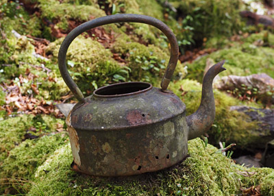
This section of track is like an outdoor museum of mining history littered with teapots, leather boots, rusted shovels, broken-down huts and other gold rush detritus.
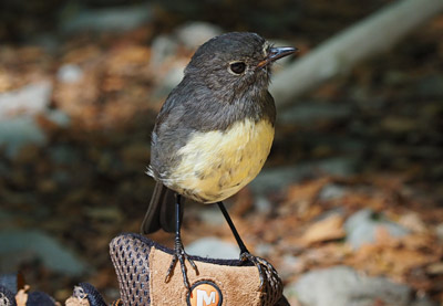
You’ll also see plenty of cheeky South Island robins. Any break is an invitation for them to hop onto your boots and try to pull out the laces or peck at the threads.
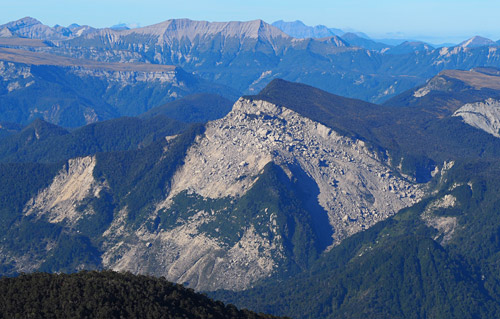
The most striking features of this part of the track are the Big Slips triggered by earthquakes in 1929 and 1968.
Lyell Saddle Hut (875m) offers fine views across the ranges, pong-free composting toilets and raucous birdsong in the evening.
Day 2: Lyell Saddle Hut to Ghost Lake Hut (12km, 4 hours)
This is possibly the best day of the Old Ghost Road (and that’s saying something) so don’t rush it.
It starts with another gentle climb through beech forest until, after just over an hour an a half, the track emerges from the tree line into flax and tussock.
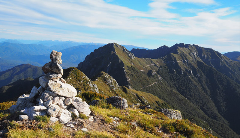
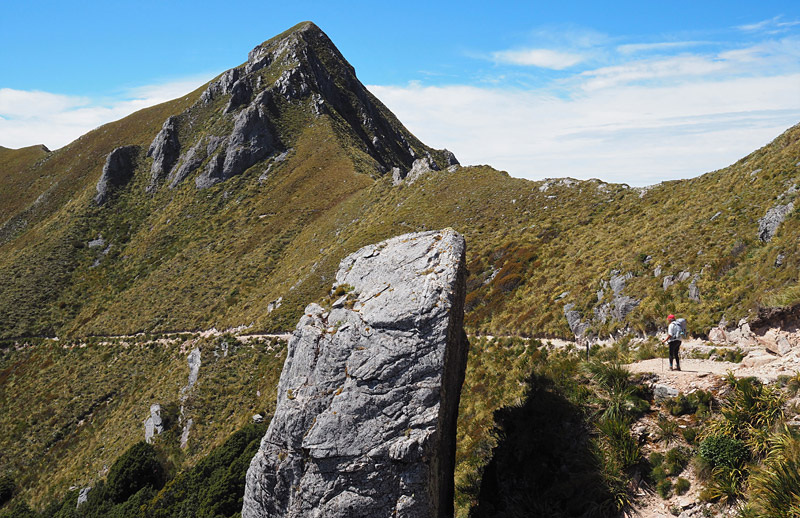
As you keep climbing and just before you reach a shelter, the Lyell Range — dominated by the sheer-sided Rocky Tor (1456m) — suddenly looms spectacularly into view up ahead.
The track then sidles around the peaks and passes a number of extraordinary sights including the Tombstone (a huge slab of rock in the shape of, er, a tombstone) and Heaven’s Door (a gap in the range framing a view of the mountains to the east). If you’re cycling you need to keep your wits about you because it’s a long way down if you leave the track.
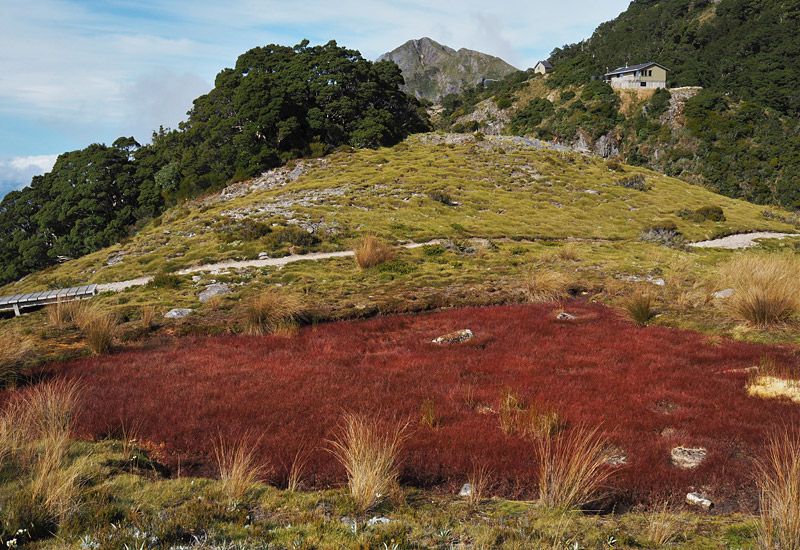
The 18-bunk Ghost Lake Hut perches above the tree line at 1220m with views to die for. It gets it name from a fairly unimpressive tarn (the term for a small lake carved out by a glacier) a short walk downhill, but there’s a much prettier one coloured blood-red by water weeds a little further on.
It’s only when you leave Ghost Lake Hut that you realise it’s perched precariously on a cliff edge, almost like a Kiwi version of Greece’s famous Meteora monasteries.
Ghost Lake is the only hut with an (almost) permanent volunteer warden. When I visited the garrulous Bruce was on duty. He had an endless supply of stories and clearly loved his role.
Days 2 and 3 could be combined to make one long day but in my opinion you’d be crazy to come this far and miss a night at Ghost Lake Hut.
If you feel like you haven’t walked far enough to justify stopping for the night, there’s a very rewarding walk to the top of the ridge behind the hut. There’s no marked track but even I could find the way.
First, find the shower. The make your way up through the trees for a short distance — you should be able to see where others have walked— until you emerge into tussock and alpine herbs. Then just follow your nose straight up a spur to the nearest peak.
It’s a bit of a scramble but once you’re on top it’s mostly easy going along a narrow ridge, with the odd rock outcrop to clamber over, to the highest point.
The 360-degree views from the top are magnificent. On a clear day you can see the entire top half of the South Island; with a map or a phone app you can pick out Mt Owen, Mt Arthur and Mt Angelus in Kahurangi and Nelson Lakes national parks.
You can also see where you’ve walked so far on the Ghost Road and where you’re about to go. This is also the only decent view you’ll get of the Boneyard, an earthquake-shattered mountainside you’ll cross on day 4.
The only place you could potentially get lost is on the way back down to the hut as you re-enter the bush. It’s worth leaving a few markers for yourself as you head up.
Day 3: Ghost Lake Hut to Stern Valley Hut (13km, 4 hours)
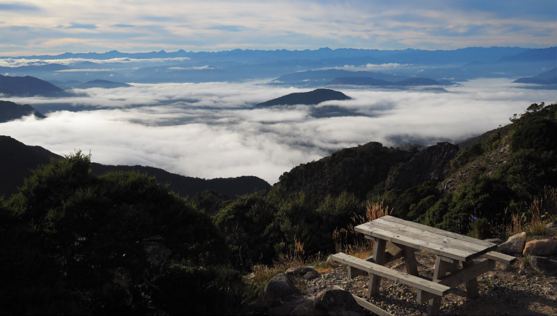
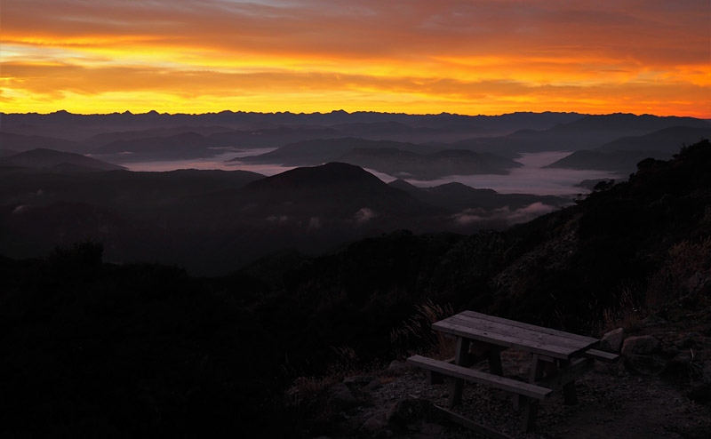
If you only get up early enough to see the sunrise once in your life, make it this day. It’s worth it to see the sun creep over the mountains and melt away the mist lingering in the valleys far below.
This is another short day so you could head up to the ridge if you didn’t do it yesterday. Or you could just laze around on the deck soaking up the view. Whatever you do, you shouldn’t be in a hurry to leave. Ghost Lake is too high for sandflies but they are waiting for you by the millions at the next hut.
Once you do get going it’s a 40 minute descent on a very rocky, zig-zag trail which then zig-zags back up to Skyline Ridge. This is a fabulous walk along a near-level ridge with steep drops on either side and great views in all directions.
The precipitous descent from the end of the ridge to Stern Valley is one challenge even the builders of the Old Ghost Road couldn’t solve in a bike-friendly way. Instead they installed 303 prefabricated wooden steps to bring you abruptly back into the arms of the forest.
From there the track descends gently as it follows Stern Creek on a thick carpet of beech leaves. Just past the 40km marker you’ll pass a pretty waterfall which makes a good lunch spot; a little further downstream you’ll find a deep green pool which makes a great place for an invigorating skinny dip. It takes a bit of bush-bashing to get to the water but there are no sandflies to spoil the serenity.
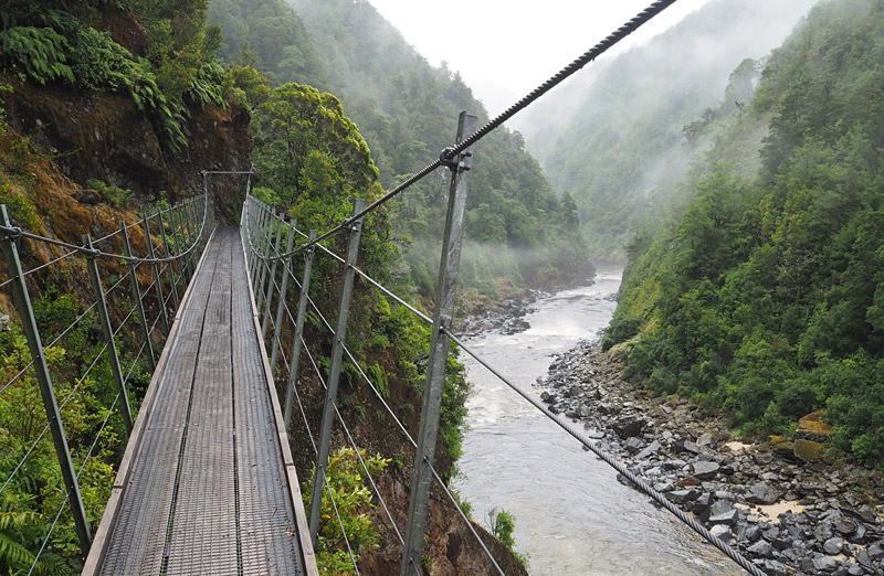
The track continues along the stream and over two suspension bridges to Stern Valley Hut. The way the balcony has been entirely wrapped in mesh is a clue how vicious the sandflies are. All the same, it’s worth exploring the creek next to the hut and staying alert for a peculiar whistling noise, especially around dusk. This is an ideal spot to see the endangered and highly elusive whio or blue duck.
[If you don’t know what a whio sounds like, click here and scroll down to the Sounds panel on the right.]
Day 4: Stern Valley Hut to Specimen Point Hut (25km, 8 hours)
The longest day of the Old Ghost Road takes you through a series of different landscapes and ecosystems.
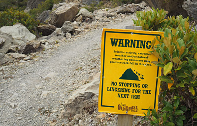
The track starts by heading up the extraordinary, earthquake-scarred Earnest Valley and over a natural dike between Lake Grim and the slightly lower lake Cheerful. It then zig-zags up the evocatively named Boneyard, where an entire mountainside has collapsed into a pile of boulders and raw, broken rock. Signs warn walkers that the area is still prone to tremors and not suitable for dawdling.
Eventually the track reaches Solemn Saddle where the landscape changes instantly.
One minute you’re walking in the open, scrubby Earnest Valley; the next you’re submerged in rainforest with a dense understorey of ferns and moss-draped trunks.
The route then descends gently through bush to Goat Creek, with a short side trip to a tiny 1950s hut across an unbridged stream which can flood in heavy rain, before it meets the Mōkihinui River and crosses an impressive suspension bridge with a possum gate in the middle.
Possums are found on both sides of the river but only one population feeds on rare Powelliphanta snails. These ever-hungry marsupials can apparently learn from each other so DOC wants to stop them mingling and sharing recipe ideas.
The tracks passes through some particularly lovely bush to Mōkihinui Forks, where the north and south branches of the river meet at a broad, grassy river flat. After Mōkihinui Forks Hut (a basic DOC hut) it’s only another 3km to Specimen Point Hut.
This hut is sited above the Mōkihinui River just before its waters funnel through a narrow gap between two bush-clad bluffs.
Day 5: Specimen Point Hut to Seddonville (17km, 5 hours)
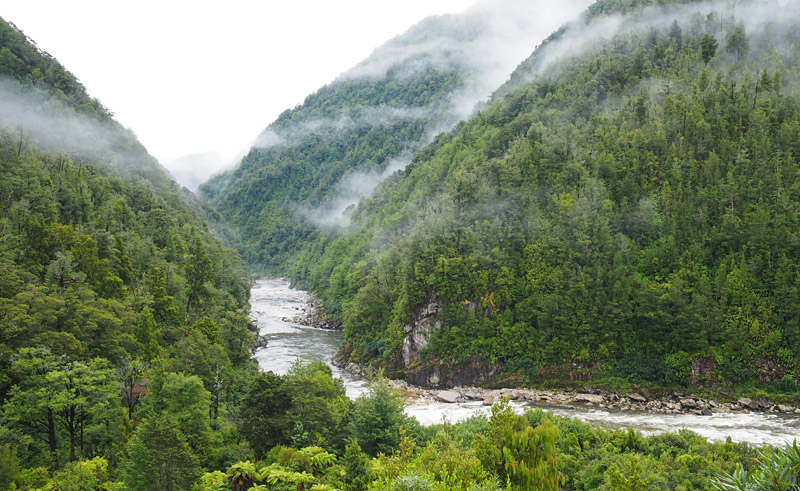
The final day of the Old Ghost Road follows the Mōkihinui River back to civilisation at Seddonville. Sometimes the track is a ledge cut into the side of a precipitous gorge with the river roaring below; at other times it passes through serene, green bush dripping with mosses, ferns and lichens.
A series of otherwise impassable rock slides, dubbed the “Suicide Slips”, are spanned by suspension bridges along the side of the gorge.
Keep your eyes on the river for gold mining remnants and the wreckage of a bridge, once part of a road to Karamea, destroyed in the 1929 Murchison earthquake.
The track ends near the Rough and Tumble Lodge where you can order a pizza and craft beer. For $10 you can also have a hot outdoor shower overlooking the river; some shuttle services will give you a voucher entitling you to a free shower.
Practicalities
The Old Ghost Rd has to be booked in advance via the official website. It doesn’t seem to get booked out six months in advance, unlike some of the Great Walks, but you still need to get in early if you’re after specific dates.
Also unlike the Great Walks, you pay a flat rate ($150 in February 2021) if you stay one night or four. All the more reason to take your time.
The huts also have tent sites and four-bunk cabins for those who want some privacy or a refuge from snorers.
The track has been designed for mountain bikes so there are few steep gradients, with the exception of the Skyline Steps, but it is fairly demanding in terms of distance (85km total with one day of at least eight hours’ walking).
You need to be reasonably fit and well prepared for the West Coast’s rapidly changing weather and high rainfall. You don’t need to take a cooker, plate, mug, pots or cutlery. All those items are provided in the main huts.
The DOC-operated Mōkihinui Forks Hut is a little more basic than the four backcountry trust huts. Goat Creek Hut is very small and not really recommended except as a historical curiosity.

The starting point, at the DOC campground at Lyell, is easy to reach on State Highway 6 in the Buller Gorge, 65km east of Westport. The end point, at Seddonville, 3km off SH67, is a little more isolated.
You’ll find some fairly upmarket accommodation (plus a good café) at the Rough and Tumble Lodge right next to the track exit. Otherwise you can continue the short distance to Seddonville, which has a campground with tent sites and dorm beds, as well as a basic pub and an even more basic shop.
Otherwise it’s about 3km to the main highway (SH67) along the west coast. A short detour north on SH67 will take you to Gentle Annie, a beachside campsite with cabins, a backpacker-style lodge and a good reputation.
If you’re hitch-hiking to Westport, about 45km south on SH67, you’ll need to allow plenty of time because traffic here can be light.
It’s likely you’ll need the services of a shuttle company to drop you off at the start and/or collect you at the finish. Most also offer a vehicle relocation service. I tried a few transport companies and only had joy with Hike ‘n’ Bike. They were flexible, the rates were fair, and the driver was passionate about the area and knew the track well.
More information
Check out the official Old Ghost Road website for pretty much everything you need to know. DOC also offers a guide to the track on its comprehensive website.
You can study up on the birdlife you’re likely to see along the track in this New Zealand Cycle Trail article.
An article published by Stuff in 2013, Spectre of Old Ghost looms large, gives a good snapshot of progress on the track at that time.
I found surprisingly little in the blogosphere about the Old Ghost Road — maybe Covid is to blame for that — but I did stumble on this account by a Canadian physiotherapist who rode the trail in appalling conditions in 2020.
Finally, for the full story of how the Old Ghost Road came about and how it was built, read Spirit to the Stone by Marion Boatwright. You’ll find his book at every hut; four nights is more than enough to finish it. If you want your own copy you can order one online at the Old Ghost Road store.
Saw this comment the other day.
Thought it might be appropriate:
“I don’t like either the word [hike] or the thing. People ought to saunter in the mountains – not ‘hike!’ Do you know the origin of that word saunter? It’s a beautiful word. Away back in the middle ages people used to go on pilgrimages to the Holy Land, and when people in the villages through which they passed asked where they were going they would reply, ‘A la sainte terre’, ‘To the Holy Land.’ And so they became known as sainte-terre-ers or saunterers. Now these mountains are our Holy Land, and we ought to saunter through them reverently, not ‘hike’ through them.”
― John Muir
Cheers Ben. A-sauntering I shall go!