Where the sun rises
The trip didn’t start well.
In fact, unless I’d been hit by a truck, it couldn’t have started much worse. A puncture before I’d even climbed on the wretched bike, and once I’d patched the hole and pedalled barely a kilometre down the road, the back tyre blew clean off the rim.
I limped my bike back to Gisborne where a man fixed it and said something about the beading not being aligned properly. Whatever. After that — and a soul-destroying day-long slog to the top of the ranges into a howling northerly — my hunt for New Zealand’s easternmost pub by bicycle could only get better.
I got the idea earlier in the summer when the roads were teeming with mad cyclists pedalling around New Zealand. Invariably German and always in pairs, they had legs like pistons and lycra-clad bodies so bronzed and taut they could have been turned on a lathe.
I figured there was no good reason why a skinny, out-of-shape reporter couldn’t share in all that scenery and exercise. So I bought the cheapest bike I could find, packed a tent and a change of underwear, and started pedalling.
The 500km East Cape circuit, possibly the most popular cycle touring route in the North Island, crosses the ranges between Gisborne and Opotiki on State Highway 2, before following the coastal highway SH35 around the Cape and back to Gisborne.
My plan was to get the worst day out of the way first — the uphill grind to Matawai, a farming settlement boasting a fine tavern crowded with historical memorabilia.
That evening my ego was crushed by a Cycling New Zealand guidebook that claimed the 70km leg was only considered to be “fairly hard” and would take 3½ to five hours. It took me seven.
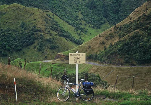
From Matawai, SH2 winds up the scrub-covered range to Traffords Hill, at 725m the highest point on the trip, before dropping into the Waioeka Gorge for an exhilarating 40km downhill run beside a churning river the colour of a spearmint milkshake.
But it was only when I’d pedalled another 15km around the coast from Opotiki that I found the East Coast of legend, where time and the pursuit of wealth have no meaning.
In Torere, a settlement that boasts possibly the world’s only combined book-bindery and pig-dog training farm, I stopped at a craft shop where a request for water turned into an hour-long conversation. Then at Hawai, a few kilometres further around the coast, I found a camping ground where the fee was $10 a night. I had only a $5 and $20 note in my wallet.
“Close enough,” said the proprietor, taking the $5 note.

Also at the camping ground were Claus and Steffi, cyclists from — yep, you guessed it — Germany. They were on a bike ride around the world, starting with the East Cape, and Steffi was in love with the place already.
“It is so beautiful,” she sighed. The ever-hungry Claus praised the easy travelling, the varied landscapes and friendly natives; all he missed was German bread.
But their demeanour changed when I asked them about New Zealanders’ driving habits.
“They are crazy,” Claus said, tapping his forehead.
“The logging trucks are very friendly when they come the other way, but when they are passing they leave only this much space,” said Steffi, indicating a distance of at most 20cm.
“The only thing that slows down to pass you is the van from the hospital,” she added, searching for the English word for ambulance.
The official East Cape holiday guide lists “good laz’n” as one of the top activities at Omaio Beach, the next settlement around the coast — but then it suggests “laz’n” for pretty much everywhere.
When I arrived the locals had only just cleared the road of driftwood left by Cyclone Ivy, and a lantern-jawed man, brandishing an umbrella like a taiaha, was riding a horse up the main drag.

Inside the Omaio store, the talk was of two young surfers who lost their lives in the cyclone, apparently lured out by the nine-metre swell. With giant logs thrashing about in the surf they didn’t stand a chance.
“It’s a sad business,” sighed the shopkeeper, as he picked up a guitar and broke into a melancholy Don McLean number: “Paint your palette blue and grey / Look out on a summer’s day / With eyes that know the darkness in my soul.”
My next stop was the pub at Te Kaha (which means “stand firm”) for a cold pint at a stunning cliff-top garden bar. Waves crashed on the rocks below and the sun blazed over a turquoise ocean, but the patrons were drinking indoors. I’ll never understand traditional Kiwi pub culture, but at least I was getting closer to the country’s easternmost pub.
The coastline beyond Te Kaha was especially gorgeous — all delightful rocky inlets and bush-covered headlands, with the only sounds the hum of rubber on asphalt, the chirping of cicadas, and the calls of tui and riroriro. That’s something you don’t get in a car.
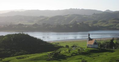
The next morning’s ride took me to Raukokore, where the 120-year-old Christ Church is beautifully sited on a rocky promontory. A note stapled to the door apologises for the fishy smell around the font, apparently the work of a “whānau [family] of penguins” under the floor.
Whangaparoa Bay, the last beach on the western side of the Cape, is also one of the loveliest. An empty sweep of white sand stretching all the way to Cape Runaway, legend says it was the first landing place of the Tainui and Arawa canoes. The signs remind visitors they are treading on Maori sand, but there are no orders to keep out — just a plea for respect.
From Whangaparoa the road turns inland for 30km, past rows of abandoned car wrecks, pockets of bush thick with tui and farmland slowly returning to scrub. It was a relief to climb the last hill and drop onto the coastal flat at Hicks Bay, a modest settlement named after a crew member on Captain Cook’s Endeavour.
The hub of Hicks Bay is an eclectic general store, brimming with gossip and laughter, a kind of informal community drop-in centre. The owners, a mellow Māori-Pakeha couple from Rotorua, seemed to epitomise the easy-going bicultural community a million miles from arguments over the foreshore and seabed.
“She’s a nice place,” agreed the bloke at the counter as I helped myself to another coffee.

The next settlement — on the other side of a hill with stunning views to the East Cape and the almost 1000-metre-high Pukeamaru Range — was Te Araroa, home to the world’s biggest pōhutukawa tree and the Kawakawa Tavern.
It was early morning and the pub was still closed, but I pressed on regardless after checking that the next pub, in Tikitiki, was slightly further east. After consulting my legs, I also decided to skip the 45km return trip on metal roads to East Cape. Next time.
The road beyond Te Araroa was brutal. It was blazing hot and each hill was steeper than the last, so I was shattered by the time I rolled into Tikitiki.
The town didn’t look too lively either. Like many places around the coast, all the shops had closed down and one was just a graffiti-covered shell. I asked for directions and a local pointed me toward a charred concrete slab at the edge of town, where New Zealand’s easternmost pub burnt down last year.
But all was not lost. A block away, the Waiapu RSA — an unpretentious, friendly kind of place where Christmas decorations were still up in March — was open for business. The walls were decorated with photos of war veterans and, upstaging even the Queen, portraits of local hero Sir Apirana Ngata and second lieutenant Te Moananui A Kiwa Ngarimu, who was awarded the Victoria Cross in 1943.
I ordered a feed and a bloke I’d assumed was one of the veterans tore himself away from the races and shuffled off to the kitchen. It was a pretty indifferent burger, but it felt great to chat to the old soldiers and savour an ice-cold lager — especially when a final check of the map confirmed I’d found the easternmost pint in New Zealand. And it cost just $2.60.
(At this point I should clarify that we’re talking about the easternmost pub on the New Zealand mainland. The prize for the easternmost pub in New Zealand goes to Hotel Chathams in Waitangi, Chatham Islands, a staggering 400km east of Tikitiki.)

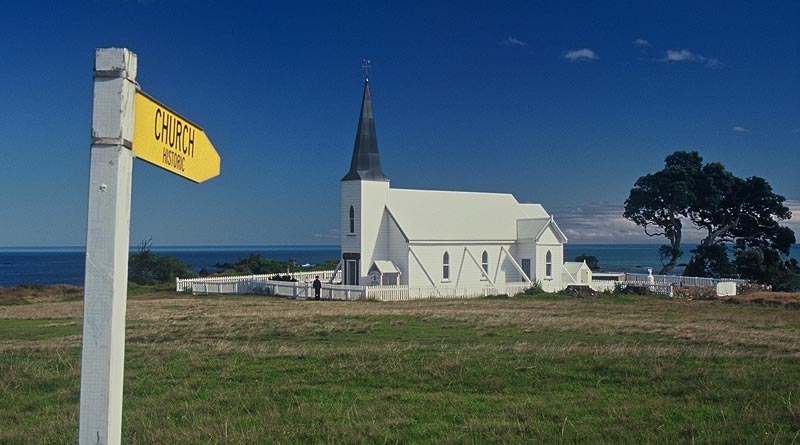
Feeling suitably refreshed, I pedalled back to Tikitiki’s St Mary’s Church, built in the 1920s in memory of soldiers of the Māori battalion. It looked pretty ordinary from the outside, but inside every square inch is decorated with carvings, tukutuku panelling and kowhaiwhai patterns. Even the stained-glass windows are based on Māori motifs. If you’re ever in Tikitiki, don’t miss this national treasure.
From there I took a detour out to Rangitukia, after a tip-off about one of the most extraordinary sights on the coast.
Parked in a paddock on a giant custom-built trailer, where the Waiapu River empties into the Pacific and admired only by cows, is the largest waka [ceremonial canoe] ever carved.
Originally named Te Aio O Nukutaimemeha and completed in 1999, the waka is 45 metres long, weighs 22 tonnes and comfortably seats 80 paddlers. It can take as many as 160 people, and is twice the size of the great waka at the Waitangi Treaty Grounds.
But now it is slowly disintegrating. The sternpost has broken off and cows are using the bow carving as a rubbing post. It’s not easy getting to the bottom of the story, but the waka’s sorry end seems to be related to an ownership dispute between the East Cape tribe Ngāti Porou and the waka’s makers.
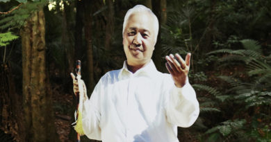
Later I caught up with its chief carver, Gisborne-based Matahi Brightwell, who said the design was inspired by the waka Te Toki-a-Tapiri, carved near Wairoa in the 1830s and now at the Auckland Museum.

“Ten years of my life went into that project. I’m just very sad … it’s like creating a child and leaving it in a paddock to fend for itself,” he said.
It’s not the first time either — another of his waka, carved for the 1990 Waitangi Day celebrations, ended up as firewood. But Matahi hasn’t given up. One of his most recent projects was a 25-metre double-hulled sailing canoe, which he plans to sail from Tahiti to Chile. In the 1980s he sailed a similar vessel from Tahiti to Hicks Bay.
If it’s any consolation to Matahi, the waka’s location suggests it hasn’t been abandoned in a random paddock. Its bow points towards the sacred mountain Hikurangi; and the nearby Waiapu River mouth was the first place on the East Coast where the gospel was heard, and where Maui first set foot when he dragged the North Island up from the sea.
That night I was the only paying guest in the 20-room Ruatoria Hotel, where the manager was the first person who’s ever seriously called me “bro”. I ate my kumara chips on the balcony, watched the sun sink behind Mt Hikurangi, and sank a few beers in the raucous bar downstairs.
I only saw one other Pākehā that night — he was looking pretty sheepish after parking his shiny new 4WD by the Kai Kart and locking the door with the engine running — but everyone I spoke to was unfailingly friendly. So much for Ruatoria’s scary reputation.
The next major settlement was Tokomaru Bay, another of those charming East Coast towns breathing decline and bygone glory. Most of the businesses, including an imposing pink stucco bank on the waterfront, had closed down long since; and a few kilometres around the bay, next to an abandoned freezing works, a wharf is slowly falling into the sea.
Built in 1910-11, the works originally handled 500 sheep and 60 cattle a day. But falling stock numbers, erosion and improved roads made it uneconomic, and it closed down in 1953. Now the bush is slowly reclaiming its vast brick and concrete shells, making a fascinating place to explore.
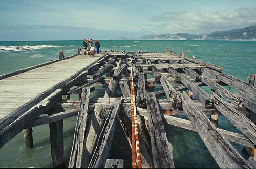
After Tokomaru Bay the dramatic scenery of the East Cape is replaced by ordinary rolling farmland, but at least the road is mercifully flat. Tolaga Bay, compared to the other townships on the route, seemed a thriving metropolis.
I camped next to its famous wharf, which at 660m is one of the longest in the Southern Hemisphere. Unfortunately, the builders used beach sand and gravel when they mixed the concrete; now the salt is attacking the reinforcing rods, which are shedding concrete like an old skin.
The last day’s ride back to Gisborne was a mere 50km. I must have started getting into shape because I was sorry to be nearing the end of my quest. Especially after the last lovely 10km, where the road is so close to the beach you can taste the spray.
That brought the distance over six painful, sweaty days to just over 500km – not bad, even if the Germans would have been halfway to Wellington by then. For a few days afterward I actually had thigh muscles, and apart from the drama of the first kilometre, the only damage was a broken spoke.
But next time I head to the pub by bicycle I’ll try finding somewhere flatter – or maybe I’ll just stick to my local.
This story was based on a six-day bike ride around the East Cape, one of the most isolated – and beautiful – places on New Zealand’s North Island. Known in Maori as Te Tairawhiti, which translates roughly as “the place where the sun shines across the water”, the people of the East Cape are the first to see the sun rise each day.