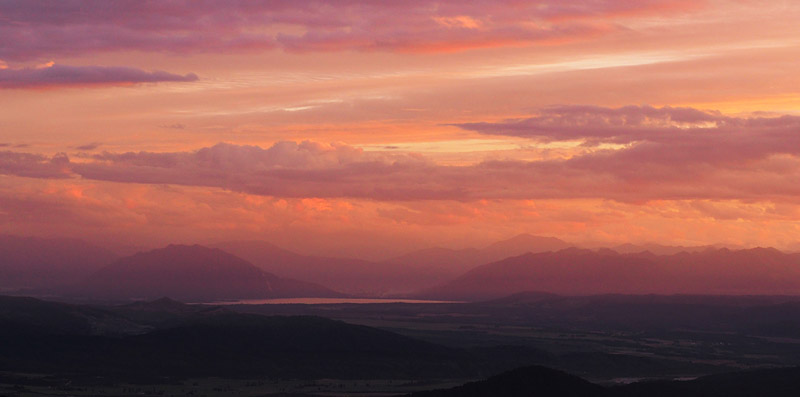
Paparoa Track: NZ’s newest Great Walk
New Zealand’s newest Great Walk was born out of tragedy.
In November 2010 a series of explosions at Pike River Mine, near the west coast town of Greymouth, claimed the lives of 29 men.
This isn’t the place to examine the causes in depth but the short version is that the mining company was under pressure to make money for its shareholders — it had overestimated the value of coal that could be extracted — and its executives were taking shortcuts while downplaying the risks of a methane explosion.
The mine was poorly designed and its safety systems never finished but, thanks to decades of government deregulation and lax enforcement by under-resourced agencies, mining was allowed to go ahead. The combination of cowboy operators and weak oversight led to disaster.
The families of the Pike 29, as the men came to be known, wanted to remember their sons and husbands but they weren’t interested in plaques or statues.
What they wanted was a lasting memorial that would create employment in a region where traditional industries, mining and forestry, were in decline.
Their idea was to create something positive out of tragedy — and so the idea for New Zealand’s 10th Great Walk was born.
When the mining company was liquidated the government acquired the land and added it to the adjoining Paparoa National Park. Plans for the track were approved in 2015.
The new Great Walk took two existing tracks from the gold-mining era, Croesus Track and Inland Pack Track, plus a trail used by uranium prospectors in the 1950s, and linked them together with a new route over part of the Paparoa Range.
Until then most of the park had been untracked and accessible only to trampers with well-honed backcountry skills.
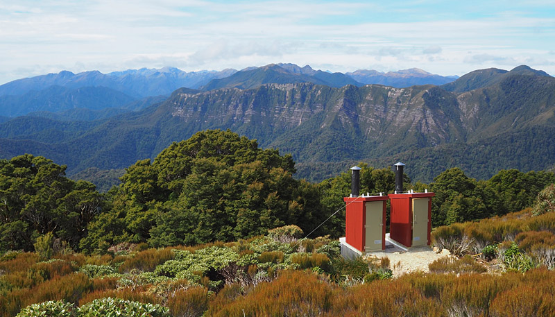
The Department of Conservation also built two new huts, Pororari Hut and Moonlight Tops Hut.
The track was completed in late 2019 but was promptly wiped out by landslides triggered by a violent storm just days before the official opening.
As a result 2020-21 was the first full summer for the country’s first new Great Walk in 25 years.
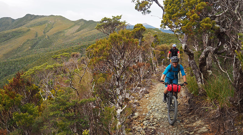
It’s also the first Great Walk designed as a dual-use trail for hikers and mountain bikers, which means it has no steep gradients (but plenty of zigzags), no steps (except those built by miners and preserved as part of the track’s history) and easy surfaces of compacted gravel (mostly).
The track passes through a variety of forest types and landscapes sprinkled with remnants of the area’s rich mining history. Features of the old gold mining trails have been preserved and new sections have been built with old techniques, including stone-lined culverts and “corduroy”, in which storm-felled trees are sawn into plank-like flitches and laid into boggy sections of track.
Eventually an 11km branch trail, the Pike29 Memorial Track, will descend to an interpretation centre at the mine portal.
I was told the memorial track is more or less finished but won’t open until the Pike River Mine recovery operation is complete.
While attempts to recover the bodies have been abandoned, as of early 2021 work was continuing to collect evidence for a police investigation. Police have told families of the Pike 29 that charges are likely.
| Paparoa highlights
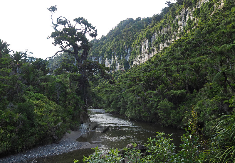
• Walking among the limestone bluffs and nikau glades of Pororari Gorge. |
Walking the Paparoa Track
The Paparoa Track is a relatively short 56km which can be walked in three days with nights at Moonlight Tops Hut and Pororari Hut. You can stretch it out by staying a night at Ces Clark Hut — that gives you two very short days but you can fill the time with a couple of rewarding side trips.
Once the Pike29 Memorial Track opens walkers will have more options for side trips plus an alternative entry/exit point.
By bike you can ride the Paparoa Track in one long day or easily in two with a night at Moonlight Tops Hut. I’ll confine myself to writing about walking because it’s what I know about.
Most people start at Blackball, inland from Greymouth, and finish at Punakaiki, on the coast midway between Greymouth and Westport.
Walking it this way, from south to north, makes sense because you start at almost 400m altitude and finish at sea level. It’s easier logistically because almost all track transport is organised this way — you leave your vehicle at Punakaiki and get dropped off at Smoke-Ho car park, near Blackball — plus walking this way gives you the option of cutting the first, mostly uphill, day in half by staying at Ces Clark Hut. That’s a particularly good idea if you’re taking kids.
However, there’s nothing to stop you walking the other way. That may even be the only way you can book a bunk at every hut. That was certainly the case for me. I’d tried to book six months ahead and found every hut booked out; when I checked again a few weeks before my summer break I saw cancellations had opened up a gap, but only if I walked in the “wrong” direction.
Walking in the recommended direction has obvious advantages but walking from north to south has some pluses too:
• The starting point at Punakaiki is on the main coastal road (SH6) so it’s easy to get to. No need for a costly shuttle.
• Because you’re walking in the “wrong” direction you have the track to yourself in the mornings (granted, that’s offset in the afternoons when you meet everyone walking the other way).
• Your first day, when your pack is heaviest, is 16km. In the other direction the first day is 20km (if you’re doing the walk in three days) with a lot more uphill.
• You finish the trip in Blackball, which has a fascinating history and is a great place to linger. It offers great food and accommodation, as well as a bunch of satisfying short walks and an outdoor museum that’s well worth visiting.
For the benefit of my fellow contrarians I’ll describe the track the way I walked it. If you are walking it the normal way you’ll just have to start reading at the end and work backwards, while remembering to convert the uphills to downhills and vice versa. If that’s too confusing you can always jump over to the DOC website and read their description.
Day 1: Punakaiki to Pororari Hut (16km, about 5 hours)
The track starts about 1km north of Punakaiki township at the Pororari River mouth. (Note that riders have a different starting point, at Waikori Rd car park by the Punakaiki River, 2km south of town.)
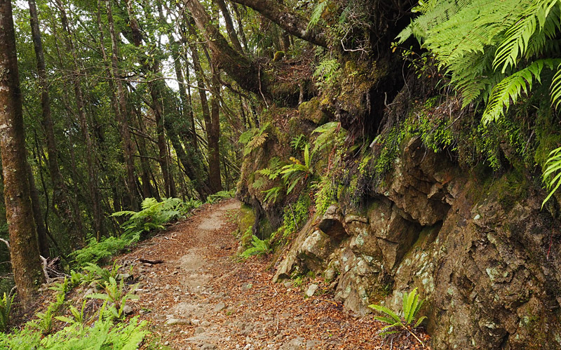
It follows a very pretty river upstream between limestone bluffs and glades of nikau palms before climbing gently to a ridge up limestone steps worn smooth by goldminers’ feet.
The track then passes through a patch of forest devastated by Cyclone Ita in 2014, a graphic illustration of the power of Paparoa Ranges weather.
After about 2.5 hours the river morphs into a series of rapids tumbling over boulders and the track zig-zags uphill through lush bush, the understorey thick with moss and ferns.
The final hour to 20-bunk Pororari Hut is a solid climb but, thanks to the cycle-friendly design, the gradient is never steep.
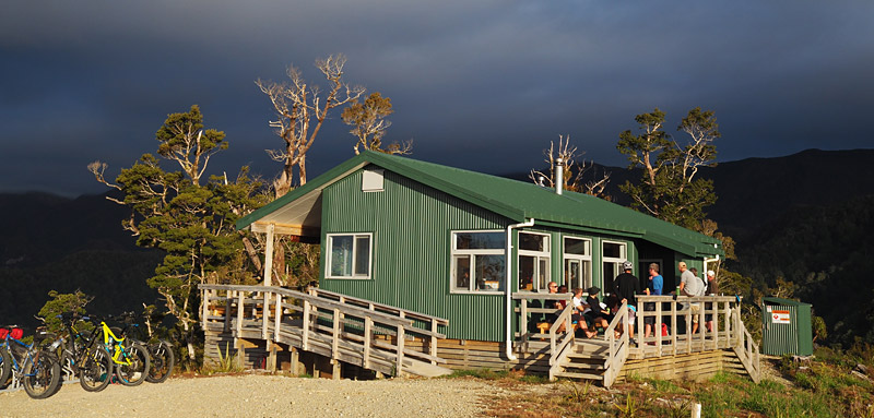
Apparently the hut used to be hemmed in by bush but two cyclones took care of that. It now perches on an exposed ridge with views out to the Tasman Sea.
You may see feral goats and you’ll definitely see lots of weka and hear their distinctive coo-eet call. These cheeky birds are especially vocal at dusk.
Day 2: Pororari Hut to Moonlight Tops Hut (19km, about 6.5 hours)
This is easily the best day of the walk. Pray to the weather gods for clear skies so you can savour the views.
The first hour climbs gently uphill on a track cut into rocky, forested mountainside. You’ll see plenty of inquisitive South Island robins (totouwai), fantails (piwakawaka) and possibly tomtits (miromiro). If you sit still enough a robin will likely perch on your boots.
After just under two hours the track crosses Waterfall Bridge where, as the name suggests, a suspension bridge spans the base of a waterfall. It’s a magical spot with water cascading down a smooth rock face among scarlet-flowering rata trees.
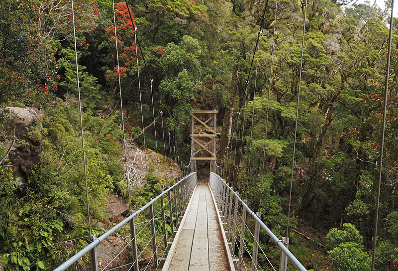
If it’s hot enough you can scramble up the left-hand side of the stream (or the true right if you want to get technical) to the bottom of the falls for a refreshing shower. Remember not to use soap because it harms aquatic life.
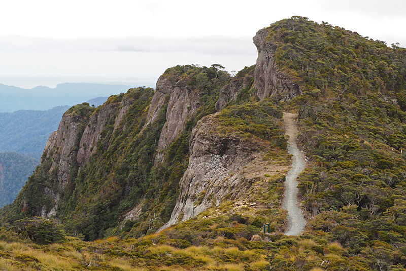
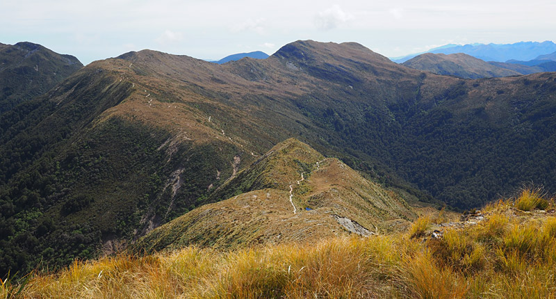
After the bridge the track climbs steadily to the top of Pike Escarpment, which stretches about 3km along the edge of a plateau with a 250m sheer drop.
Once up on the plateau the track hugs the edge of the escarpment through stunted mountain beech like a bonsai forest. Savour the views, they’re among the best on the track. When you reach an emergency shelter you’re about halfway.
The track then follows a ridge around the headwaters of the Pike Valley where you can see the remains of a mine ventilation shaft. If it looks familiar that’s because a photo of flames billowing from the shaft after the second explosion in November 2010 became the iconic image of the disaster.
While I was there (February 2021) a continuous mechanical roar could be heard from the mine workings. I don’t know if it was from the ventilation fan or machinery used in the recovery.
After the plateau the track zig-zags uphill again, this time through a “goblin forest” of twisted beech trees draped in mosses and lichens.
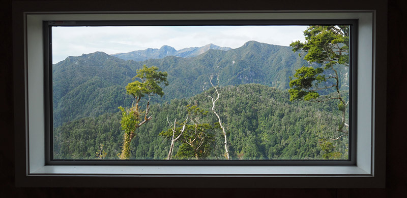
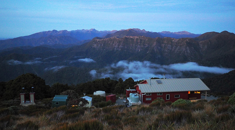
Once the track pops out above the treeline it’s only another 1.5km to Moonlight Tops Hut, from where you have an unobstructed view all the way back along the escarpment to Pororari Hut, which looks impossibly distant.
If you’re not too exhausted it’s worth spending some time on the deck after dark listening out for great spotted kiwi, the second largest of New Zealand’s five kiwi species. I heard at least four, including a raucous male-female duet, starting about half an hour after nightfall.
If you don’t know what a great spotted kiwi sounds like have a listen to this before you go (scroll down to the ‘Sounds’ panel on the right).
Day 3: Moonlight Tops Hut to Ces Clark Hut (10km, about 2.5 hours)
The track starts with a gentle climb which then sidles around the Moonlight Tops. It’s above the bushline all the way so you’ll be rewarded with great views over the Grey Valley.
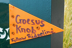 After just over two hours you’ll reach the turn-off to Croesus Knob (1204m). About 500m along the side track you’ll reach a DOC sign giving the time and distance to Mt Watson. From the sign you need to backtrack about 5m (an orange marker points the way) where you’ll see a series of poles marking the route up a ridge past more mining detritus to the top of the knob.
The route up the knob is a bit of scramble and not suitable for bikes. It takes about 15 minutes to reach the top, which offers fabulous views over the Paparoa Range and Grey Valley.
The knob got its name from a mine dug into its flanks in the late 19th century. Croesus was an ancient king known for his wealth so the name was a slick bit of marketing by the mine owners.
Once you’re back on the main trail it’s only another half an hour, downhill all the way, to Ces Clark Hut.
Unlike the other two huts, which were purpose-built to Great Walk standards, Ces Clark Hut was built by the Forest Service in the 1970s and opened by legendary New Zealand Prime Minister David Lange, though he was not known for his fondness for tramping or other forms of physical exertion.
This cosy hut has 16 bunks in an open plan arrangement around a kitchen and wood burner.
The deck offers more great views, this time across the Grey Valley to Lake Brunner/Moana with the Southern Alps in the distance.
Note that days 3 and 4 can be combined into one mainly downhill day of about 20km.
Day 4: Ces Clark Hut to Smoke-Ho car park (10km, about 2.5 hours)
This is a relaxing 2.5 hour descent through beech and red-tinted rata forest with an exit at Smoke-Ho car park, about 8km from Blackball.
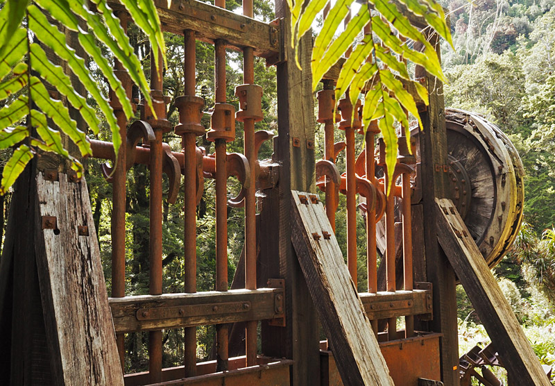
There’s a worthwhile side trip to lush Garden Gully which boasts an old miner’s hut and, on the other side of a suspension bridge, a water-driven stamper battery used to crush ore. The battery dates back to 1905 but is in remarkably good condition.
Just beyond the hut is a chest-deep swimming hole where the water is, to put it mildly, a refreshing temperature. There are no sandflies to ruin a skinny dip.
Practicalities
All huts on the Paparoa Track have to be booked in advance. Pororari Hut and Moonlights Tops Hut tend to be booked out well in advance (see the Pitfalls section below).
Most walkers and bikers start at Smoke-Ho car park at the southern end of the track. The easiest way to do that is to leave your vehicle at Punakaiki and use a shuttle service to get to Smoke-Ho.
One of the most popular services is Paparoa Track Transport which leaves Punakaiki Beach Camp at 8am and 3pm daily. The $80 fee (February 2021 price) includes bike transport and a hot shower at the end. If you’re walking the other way they can pick you up at Smoke-Ho. Other transport providers include Paparoa Shuttles.
If, like me, you finish at Smoke-Ho and don’t have a car to worry about it, it’s 8km by road to Blackball. There’s not much traffic but anyone who does pass is almost guaranteed to give you a ride.
I’ve already mentioned the charms of Blackball; once you’re done with them, it’s less than 2km to the main road. From there it’s fairly easy to hitch-hike to Greymouth (25km).
If you need to get back to Punakaiki it’s another 50km up the coast. East West Coaches offers a daily trip for a decent price.
Paparoa pitfalls
The two main huts on the Paparoa Track are booked out months in advance. Unless you’re happy to carry a tent you have to book your bunks as soon as bookings open in June.
If, like me, you’re not that organised, you’ll have to rely on luck and cancellations. Keep checking the DOC booking website and be open to walking the track in reverse if a gap opens up in that direction.
There are a few reasons why it’s so hard to get a booking. It’s a new track so a lot of people want to check it out, plus Covid-19 border closures mean more Kiwis than usual are exploring their own backyard.
A planning error also seems to play a part, however. Walkers need to stay at both Pororari Hut and Moonlight Tops Hut but riders usually book only Moonlight Tops.
That means Moonlight Tops is always full, even when bunks are empty at Pororari Hut — but they’re no use to walkers if they can’t stay at Moonlight Tops.
The answer would have been to make Moonlight Tops Hut bigger than Pororari Hut to stop it becoming a bottleneck. At present both have 20 bunks. Hopefully that can be fixed in future.
Like any multi-use track there’s potential for conflict between different users. However, I didn’t notice any friction. In theory bikes are supposed to give way to walkers but in practice walkers step to the side. Every rider I encountered gave me plenty of warning then told me how many more bikes were coming.
Long-term the biggest problem with the Paparoa Track is likely to be the kind of extreme weather that wiped out a section of trail days before it was supposed to open. There’s not much mere mortals can do about that, apart from pray for good weather and hope for speedy repairs after the next big storm hits.