Auckland’s island escape: Great Barrier’s Aotea Track
Do you fancy a hiking holiday on an unspoiled island, but your budget doesn’t quite stretch to Bora Bora or the Greek islands?
In that case — if you live in northern New Zealand anyway — you could do a lot worse than a trip to Great Barrier Island (known as Aotea in te reo Māori).
At 285sq km it’s a little bigger than Niue and about the same size as the Greek island of Kos. It’s the sixth-biggest island in New Zealand after the South Island, the North Island, Stewart Island, Chatham Island and Auckland Island.
This off-grid island is home to fewer than 1000 people who rely on the sun and generators for power. Its once great kauri forests were almost entirely destroyed by rapacious logging companies but about 60 per cent of the island is now protected as conservation land and the trees are slowly returning.
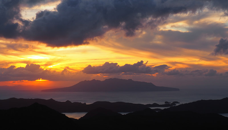
It boasts spectacular white sand beaches, hot springs and raucous bird life, but it’s also easy to access — it’s a mere 100km from downtown Auckland — with some great cafés and even a lively Irish-themed pub.
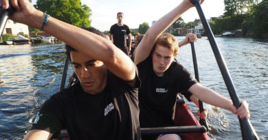
It also has some fabulous walks which is, of course, why it features on this blog. In fact, I’d rate Great Barrier Island’s Aotea Track as the best multi-day walk in the Auckland region. (If you know a better one, please let me know!)
One of the great things about the Aotea Track is its flexibility. You can walk it as a north-to-south traverse (or vice versa) or as a loop with any number of starting points. You can even do it as a day hike and see all the best bits in a mere 7-8 hours’ walking.
Great Barrier has two DOC (Department of Conservation) huts which means you can do a three-day walk without having to carry a tent or even a cooker (both huts have gas stoves). The island also has several DOC campgrounds, all in scenic locations.
Walking the Aotea Track
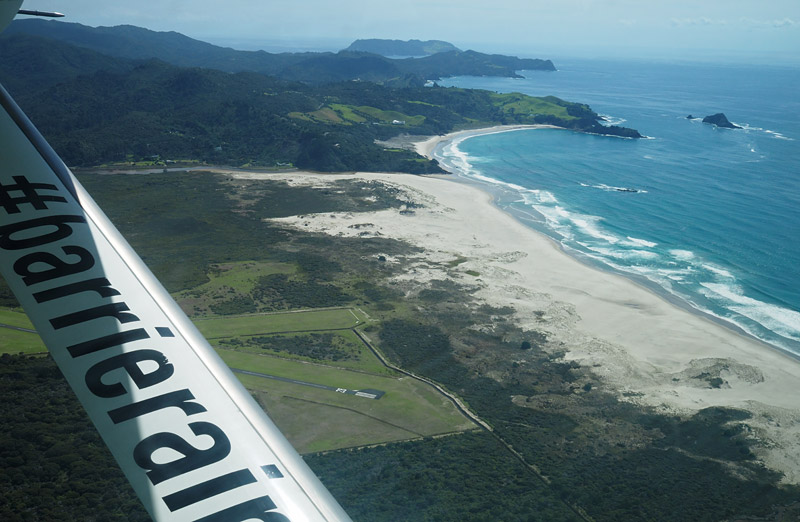
Unless you have your own boat you’re likely to arrive at the southern end of the island. The ferry docks at Tryphena, in the island’s southernmost harbour, while the plane lands at Claris, about 10km further north.
You can hire a car at either location or rely on hitch-hiking. Hitching is fairly easy but the island is deceptively large and there isn’t much traffic once you get off the main road from Tryphena to Port Fitzroy.
I didn’t have access to a car so it made sense for me to walk a loop that started and finished in the south. I also wanted to finish at Kaitoke Hot Springs. Those two factors, plus time constraints, determined my route.
I’ll describe the way I walked but this is only one of many possible variations.
| Aotea Track highlights
• Taking in the view from Hirakimata (Mt Hobson), the island’s highest point. |
Day 1: Claris to Kaiaraara Hut
The beauty of landing at an airport like Claris is there’s no mucking about after you land. You just grab your pack from the trolley and start walking. There’s a handy water cooler in the airport lounge if you want to top up your bottles before you start.
Turn right onto the main road and you’ll soon hit the commercial centre of Claris. If you want a caffeine fix before you hit the bush, a café called my My Fat Puku is your last chance.
Turn right when you reach Blind Bay Road, then hang a left almost immediately onto Whangaparapara Road and just keep walking.
You can start your Aotea Track adventure on any of the three tracks that start on Whangaparapara Road.
The first leads to Kaitoke Hot Springs but that’s where I wanted to finish so I kept walking to Forest Road (a dirt road open only to hikers and mountain bikers). With one short ride from a passing car it took me an hour to get there from Claris.
If I’d had more time up my sleeve — I’d caught an afternoon flight from Auckland so it was after 2pm when I started walking — I could have carried on down Whangaparapapa Road to Tramline Track South, which may be more interesting though also a little longer.
Whichever starting point you choose you’ll need to clean your boots at a kauri dieback station before you enter the bush.
Forest Road starts with a long, steady climb. It’s not particularly interesting bar the occasional view and the screeching of kākā, a native parrot that’s rare on the mainland but extraordinarily common here.
After 1¼ hours you’ll reach a junction and a choice. Kiwiriki Track will also take you to Kaiaraara Hut but it’s longer and appears to involve more ups and downs. It’s also a bush track as opposed to a dirt road so it’s probably more rewarding, but I was short of daylight so I stuck to Forest Road.
Even if you are short of time there’s one short detour you shouldn’t miss.
From the same junction a 10-minute side track leads to the summit of Maungapiko. This hill is only 280m above sea level but the last part of the trail is an enjoyable scramble on bare rock, rewarded by near 360-degree views of regenerating kauri forest and towering lava plugs left by extinct volcanoes. In the distance you’ll see the harbour arms and islets of Port Fitzroy and, beyond that, the nature sanctuary of Little Barrier Island.
I arrived at Kaiaraara Hut at 6pm, just under four hours (including breaks) after donning my pack at the start of Forest Road. If I’d started in the morning I would’ve taken a longer route.
Kaiaraara Hut appears to be an old Forest Service hut which has been upgraded. It’s in a secluded, shady spot in a bush clearing near a stream. It has one large room with a gas stove and wood fire and a 14-bed bunkroom on either side. There’s a swimming hole nearby if you need a wash.
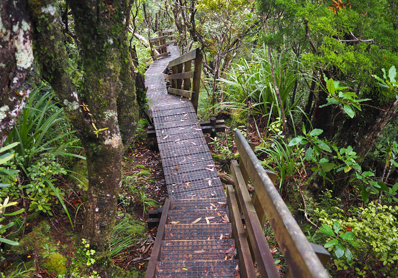
A 30-minute track from the hut leads to Bush’s Beach. It’s a pleasant stroll, much of it on boardwalks, though the beach itself is underwhelming.
Day 2: Kaiaraara Hut to Mt Heale Hut
If day 1 is a slog to get you deep into the Barrier bush, day 2 is when the real fun starts.
After crossing a swingbridge you follow Kaiaraara Stream inland, passing a remnant of the Kairarara main driving dam. This once huge structure, used to create flash floods and wash kauri logs to the coast, was originally 40m wide and 14m high but now only the base remains. You’ll also pass a side track to Cooper’s Castle (don’t bother, you’ll get much better views later).
Eventually the track starts climbing to the island’s main ridge. I don’t think I’ve ever seen so many stairs. I lost count after the first half hour or so. It’s obvious extraordinary effort and expense has gone into making the track safe and, more importantly, protecting the forest from kauri dieback disease.
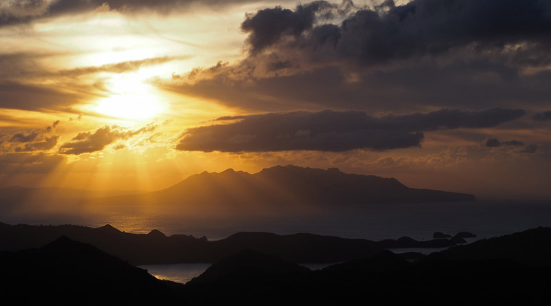
About 2½ hours after leaving the hut, not counting breaks, you should find yourself on the viewing platform atop Hirakimata (Mt Hobson). At 621m above sea level this is the highest point on the island. The near 360-degree view encompasses the island’s green interior, the airstrip at Claris, a sweep of deserted white-sand beaches and rugged Little Barrier 30km to the west.
When I got to the top, however, Hirakimata was shrouded in mist and rain. Unsurprisingly, given the mountain’s height and location, it’s a bit of a weather magnet. The mountain catches clouds blowing off the Pacific Ocean to the east and wrings out the rain.
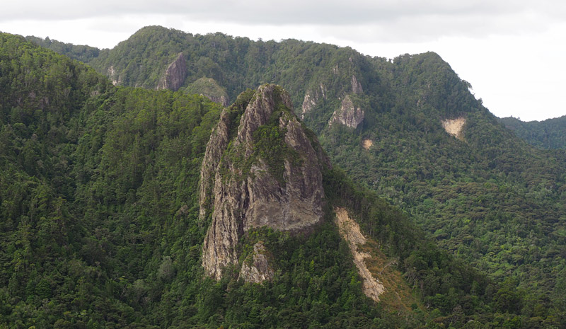
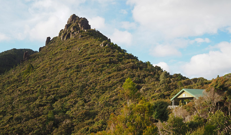
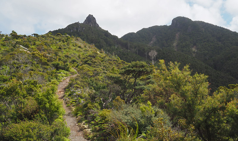
From the top it’s a steep, 30-minute descent on another extraordinary series of staircases and boardwalks clinging to the island’s main ridge. Mt Heale Hut nestles in a saddle between Hirakimata and the rocky spire of Mt Heale, another remnant of an ancient volcano.
In case you’re wondering, there are 964 stairs from the summit to the bottom of a slip where the descent ends. And that’s only one short section of the Aotea Track. In total I’m guessing there must be well over 3000 stairs.
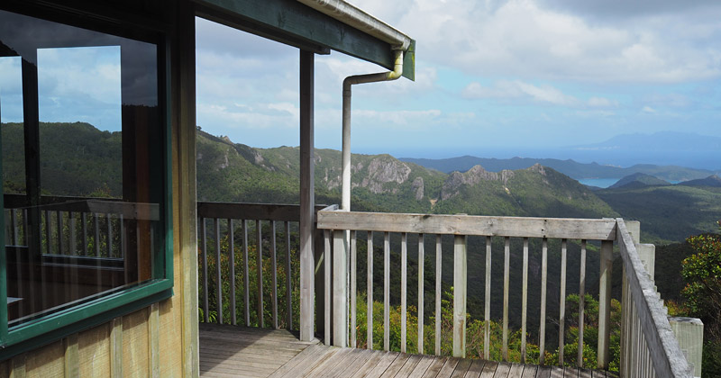
Staying at newly built Mt Heale Hut is a highlight of the walk. Its large deck is a fabulous place to watch the sun set over Little Barrier while inside the hut boasts gas cookers, solar-powered lighting and two bunkrooms. If you’re lucky, like me, you’ll meet awesome people and have some great conversations.
Day 3: Mt Heale Hut to Kaitoke Hot Springs
From Mt Heale Hut, Peach Tree Track descends from the ridge through what appears to be regenerating farmland. The low scrub means you enjoy unimpeded views back to Hirakimata and Mt Heale amid a primeval landscape of rock towers and spires.
After about an hour you’ll meet up with Tramline Track North, originally cleared for (you guessed it) a tram line for hauling timber out of the forest. Then it’s an easy walk through mānuka, kānuka and nikau forest to the Kaitoke Springs turn-off.
The track skirts around the biggest, best-preserved wetland on the island, before surprising you with one last, unwelcome uphill slog before you reach the hot springs at the confluence of two streams.
The point where the streams meet is muddy and uninviting but a short distance upstream, in the bigger creek especially, you’ll find a series of pools. If the water’s not hot enough to your liking just keep heading upstream and testing the temperature. It’s a wonderfully relaxing way to end a hike.
From the springs it’s a 45-minute walk on an easy track back to Whangaparapara Road. The whole walk from Mt Heale Hut, not counting breaks, should take about four hours.
Aotea’s one-day wonder
As mentioned earlier, the beauty of Aotea Track is its almost endless variations. If you don’t want to carry an overnight pack you can even see all the best bits in one long-ish day — all you have to do is organise transport at either end.
The ultimate one-day version starts at the impressive, and aptly named, Windy Canyon Lookout Track, which starts on Aotea Road 18km north of Tryphena. From the lookout, follow Palmer’s Track to the summit of Hirakimata/Mt Hobson, then descend the many stairs of South Fork Track to Mt Heale Hut, a suitable spot for lunch. The rest is the same as day 3 of the route described above, which ends with a soak at Kaitoke Hot Springs.
More information
Fore more information check out DOC’s Aotea Track guide.
The tracks are well marked so you can get away without a topographic map. The map in DOC’s downloadable track brochure is perfectly adequate.
For general information about Great Barrier Island check out the island’s useful visitor website.
Getting there
Regional airline Barrier Air flies up to five times a day from Auckland to Claris in a 13-seat Cessna Grand Caravan. Every seat’s a window seat, which is just as well because the views are stupendous as the plane swoops in low over Kaitoke Beach.
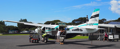
The flight takes half an hour and costs around $140 one way or $99 if you can grab a special fare (2022 prices).
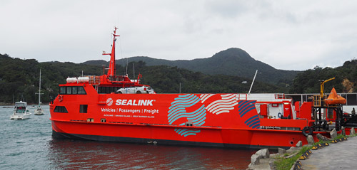
Alternatively, you can take the Sealink ferry from Auckland’s Wynyard Quarter to Tryphena (the dock is about an hour’s walk from Tryphena township).
The crossing takes about 4½ hours and costs $96 for a foot passenger or about $300 to take a car.
In summer the ferry leaves Auckland most days at 8am and officially departs Tryphena at 3pm, but it’s best to be there by 2.15pm because it can leave early if it’s fully loaded.
There are plenty of seats on deck and inside, and in good conditions it’s a pleasant trip with great views of the outer Hauraki Gulf and huge flocks of sea birds skimming low over the water.
In rough weather, however, be prepared to make copious use of the vessel’s supply of sick bags.
Check out Sealink’s website for exact departure dates and times. You’ll need to book if you’re taking a vehicle but foot passengers can usually just turn up.
If you don’t have your own transport and you don’t fancy hitch-hiking, the People and Post bus travels the length of the island every morning.
Where to stay
Great Barrier has a good range of B&Bs, lodges and baches for hire. There are, however, only a handful of backpacker lodges and budget options. The only backpacker hostel open in the Tryphena area when I visited was the somewhat tired but welcoming Stray Possum Lodge on Cape Barrier Road near the ferry dock.
If you’re walking the Aotea Track you’ll need to book the huts in advance. At $15 a night (2022 price) it’s great value. The gas stoves mean you don’t even have to carry a cooker.
Note that using the pointlessly complex hut booking site can be frustrating so don’t try to book minutes before you head off to the airport. I had to battle a strange bug that decided every date I tried to book was in the past and hence unavailable. I just kept refreshing the page and trying again until it worked. In another strange glitch you’re sometimes required to fill out a field stating the number of cars you’re bringing. Good luck getting to either hut by car.
If you have a tent the island has six DOC campings, all in scenic locations.
If you’re after a feed, Tryphena’s Pa Beach Café is possibly the best café on the island. A few paces further from the waterfront you’ll find Currach Irish Pub, a lively Irish-themed pub with fine food.
Wildlife
Great Barrier has no possums, stoats, ferrets, weasels or Norway rats so it should be teeming with birds. (It does, however, have ship rats and feral cats.)
The island has an extraordinarily healthy population of kākā, a native bush parrot all but absent from the mainland. Their raucous screeching and whistling is likely to be the soundtrack to your walk.
Another species Great Barrier has in abundance is the banded rail. I saw more in half an hour at Tryphena than I’d seen in the rest of my life. These attractively patterned birds are usually shy in the bush but in Tryphena they’re almost as cheeky as weka in other parts of New Zealand. They can fly but do so reluctantly.
Given the lack of stoats I was surprised to see or hear very few other birds. Maybe the feral cats got them all.
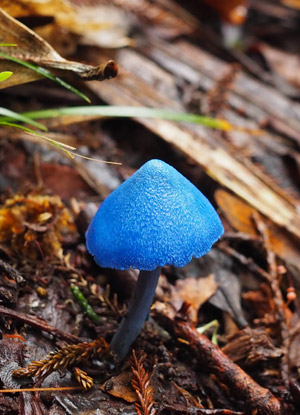
When you’re in the bush, especially along the main ridge, keep an eye out for an extraordinary little fungus. The native mushroom Entoloma hochstetteri has an intense blue colour rarely seen in nature. It’s known to Māori as werewere-kōkako because it’s the same colour as the wattles of the kōkako, a rare and melodious bird. It also features on New Zealand’s $50 note.
For more stories about walks in northern New Zealand, check out Te Paki: New Zealand’s top hike, Walking New Zealand’s Hokianga Coastal Track, and Getting high in Northland: A peak-bagger’s guide to the North’s 10 highest mountains.